Cognition of Divine Intent is the fundamental variable that distinguishes the human species from all other species. Reincarnation of the cognition of Divine Intent results in consciousness of ancestral orientation (Allen 2007).
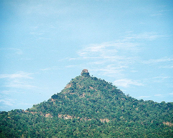
It was at New Kuruksetra that the cosmic axis, symbolized by Lingaparvarta and uniting heaven and earth, was grounded into reality and patronage to the Hindu god Siva would be symbolized as the royal linga for the Khmer empire. New Kuruksetra would become a center for royal patronage for the next 900 years if not longer and not only would New Kuruksetra become a holy place of pilgrimage it would also spawn a unique synthesis between the ancestor sprits of their sacred mountain and the Hindu gods. Seeing New Kuruksetra from this light one can observe a unique panorama of the Vedic scriptures carved in stone, and the engineering and building techniques are practically unaltered making the Champassak region one of the best archaeological sites in SE Asia to witness the growth of an ancient city with Indian roots (Zolese 2004).
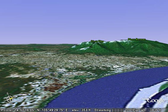
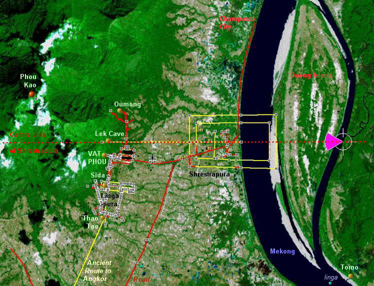
Let us now look at New Kuruksetra as seen today from the perspective of the Google Earth internet program (fig. 5.).
In many ways the land in the pre-Angkorean kingdom is still the same. The mountains are the same, the river is the same (but has changed course), the caves are the same, and the fertile plains of the ancient city are the same. In fact the only thing that's really changed is the deterioration of the temples. But there are enough remains to indicate the profound influences from pre-Indian and post-Indian origins. However, the pre-Indian elements are what brought about a new influence to the Hindu way of seeing the universe at New Kuruksetra. Those elements were the ancestor spirits stemming from the older megalithic culture of the Mon people in the area and the sacredness of the holy mountain with its natural menhir protruding from the peak (Wales 1961). According to Wales (204) "we find preserved what virtually amounts to the pre-Indian holy place on to which Hindu concepts were grafted", resulting centuries later as a unique terraced structure honoring the holy mountain.
Shrestrapura:
From the early foundation period of the ancient city, starting from the 5th century up to the present day, there are still visible defining ground plans and temple structures. In fact the ancient city is one of the best examples of early urban planning in Southeast Asia. The later monuments dating from the 9th to the 12th century including the two quadrangular palaces and the central shrine atop the axial causeway are still in good condition but the structures have weakened considerably. The decorative motifs representing scenes from the Mahabharata and Ramayana are in excellent condition. However, the most striking feature defining Vat Phu is the ceremonial road (fig 6.) beginning at the cruciform platform/embankment facing the west side of the baray.
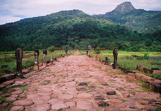
The ceremonial road leads for 300 meters before reaching the esplanade which is flanked by the north and south galleries of the palaces. The 2nd stage (fig.7.) of the terraced causeway is flanked by regularly placed stone lotus columns 27 per side making a total of fifty four.
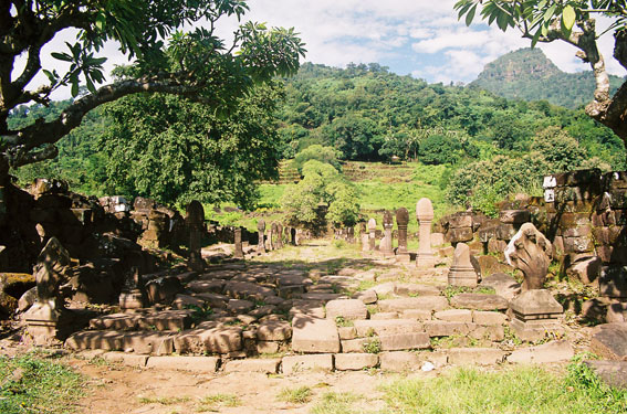
The causeway runs up the side of the mountain until it reaches the entrance of the central shrine. To state again, it is the axial causeway at Vat Phu which is unique for a Khmer temple and exists in only a few other temples namely Preah Vihear and Phnom Rung. The aspects of Vat Phu that concerns us here are the alignments of the temples with the spring and autumn equinoxes and the winter solstice. By using a Global Positioning System (GPS) measurement system based map for the ancient city (fig.8.) it was possible to accurately determine the east/west orientation of the ancient city aligned with Tham Lek Cave and the village of Ban Loang kao on the present river front (Mollerup 2007).
Mollerup state that "the planning of the landscape reflects the religious beliefs and symbolic world view of its rulers. The use of the area is not purely utilitarian but strongly reflects the Hindu view of the world prevailing in the 5th to 12th centuries AD. Inspired by the natural linga at the peak of Phou Kao Mountain, the rulers of the area planned their world around it and engineered the landscape to conform to a very specific spiritual template. The Lingaparvata provided the focal point of the whole and symbolized Mount Kailasha, the sacred mountain dwelling of the god Shiva, while the Mekong River, the other great natural feature of the landscape, represented the Ganges River and the surrounding universal ocean. The plan between the mountain and the river formed Kuruksetra, the "Holy Land".
Mollerup determined that the sun would rise over the southern wall of the ancient city at the vernal equinox and rise over the northern wall during the autumn equinox. This same principle was also used by Suryavarman II when he placed the two palaces (quadrangular courts) on the temple ground flanking the axial causeway and two barays east of the causeway. The northern baray reflects the sun during the summer solstice and the baray aligned next to the axial causeway reflects the sun during the vernal equinox. This is another example of how astronomy was incorporated into the Vat Phu complex.
Chhom Kunthea's valuable epigraphic research comparing the inscriptions at New Kuruksetra with place names in Kuruksetra, India suggests that the gurus who helped the early kings to divinize the thirthas and temple sites made use of appropriate equivalents to those in India (Kunthea 2005: 50). It is to be noted that Tham Lek cave which is going through the center of the ancient city.
The next astronomical GPS alignment Mollerup discovered was the peak of Phou Kao mountain (Lingaparvata), Tham Lek cave and Tomo temple are also aligned. (fig. 9.)
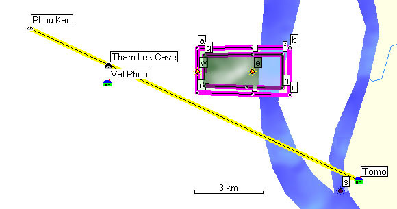
At Tomo temple there is a mukhalinga. It is the only one in Southeast Asia with four faces of Shiva looking in the four cardinal directions. There are no inscriptions on the linga nor are there any records as to why it was placed in the temple. But we can recognize the alignment with Lingaparvata symbolizing Shiva's sacred mountain as the cosmic pillar or axis of the world. Tomo is aligned with Lingaparvata with the universal ocean (Mekong River) flowing in between. Beneath the surface of the water, and opposite Tomo temple in the middle of the Mekong River, lays an image of Vishnu carved on one of the river stones found by Mariele Santori in 1996. The image is oriented toward Lingaparvata and next to Vishnu on the river bottom are many pieces of stone lingas assuring the Mekong (Ganges) would always be anointing the Shiva lingas. Similarly the sacred spring behind the main shrine constantly anointed a Shiva linga. There can be no better example of how the Brahman priests used the natural landscape to mirror the heavenly abode of the gods. The sculptured piece of Vishnu asleep on the universal waters (fig.10.) is one of the many carvings held in the Vat Phu museum demonstrating how the cosmic message in the Mahabharata was incorporated into the temple carvings.